Unlocking the Potential of Infrastructure Mapping with Aerial LiDAR

Aerial LiDAR
In the ever-evolving world of infrastructure development, precision, efficiency, and reliability are paramount. Enter Aerial LiDAR (Light Detection and Ranging), a groundbreaking technology that is transforming the landscape of infrastructure mapping. But what makes Aerial LiDAR so indispensable for this purpose? Let’s delve into the myriad advantages it offers.

What is Aerial LiDAR?

Aerial LiDAR involves mounting a laser scanner on an aircraft, such as a drone, helicopter, or plane. The scanner emits laser pulses towards the ground, which then bounce back to the sensor after hitting various surfaces. By measuring the time it takes for the pulses to return, the system can calculate distances and generate highly accurate, three-dimensional representations of the terrain and structures below.

Key Benefits of Aerial LiDAR for Infrastructure Mapping

1. High Accuracy and Precision

One of the standout benefits of Aerial LiDAR is its unparalleled accuracy and precision. Traditional surveying methods can be time-consuming and susceptible to human error. In contrast, LiDAR provides highly accurate data points, often with a vertical accuracy of up to 10 centimeters or better. This precision is critical for infrastructure projects, where even minor errors can lead to significant cost overruns and delays.

2. Rapid Data Collection

Time is of the essence in infrastructure projects. Aerial LiDAR can cover large areas quickly, collecting millions of data points in a fraction of the time required by ground-based surveying methods. This rapid data collection translates to faster project timelines, enabling engineers and planners to make informed decisions more swiftly.

3. Accessibility to Difficult Terrain

Some infrastructure projects are located in challenging or inaccessible areas, such as dense forests, mountainous regions, or urban environments with numerous obstacles. Aerial LiDAR can effortlessly survey these difficult terrains, providing comprehensive data without the need for physical access. This capability ensures that no area is left unmapped, regardless of its accessibility.

4. Detailed and Versatile Data

Aerial LiDAR generates detailed and versatile data that can be used for a wide range of applications. From creating topographic maps and digital elevation models (DEMs) to identifying potential hazards and planning construction activities, the data can be tailored to meet the specific needs of any infrastructure project. The 3D models produced by LiDAR are invaluable for visualizing complex environments and planning precise interventions.

5. Cost-Effectiveness

While the initial investment in Aerial LiDAR technology might seem substantial, it often proves to be more cost-effective in the long run. The rapid data collection, reduced labor costs, and minimized risk of errors contribute to significant savings over the project’s lifecycle. Additionally, the ability to detect issues early and plan accordingly can prevent costly delays and rework.

6. Environmental Impact

Aerial LiDAR is a non-invasive surveying method, making it environmentally friendly. It minimizes the need for extensive ground-based operations that can disrupt natural habitats and ecosystems. By reducing the environmental footprint of surveying activities, Aerial LiDAR aligns with sustainable development goals, ensuring that infrastructure projects are both efficient and eco-conscious.

Real-World Applications of Aerial LiDAR in Infrastructure Mapping

The versatility of Aerial LiDAR makes it suitable for various infrastructure applications, including:

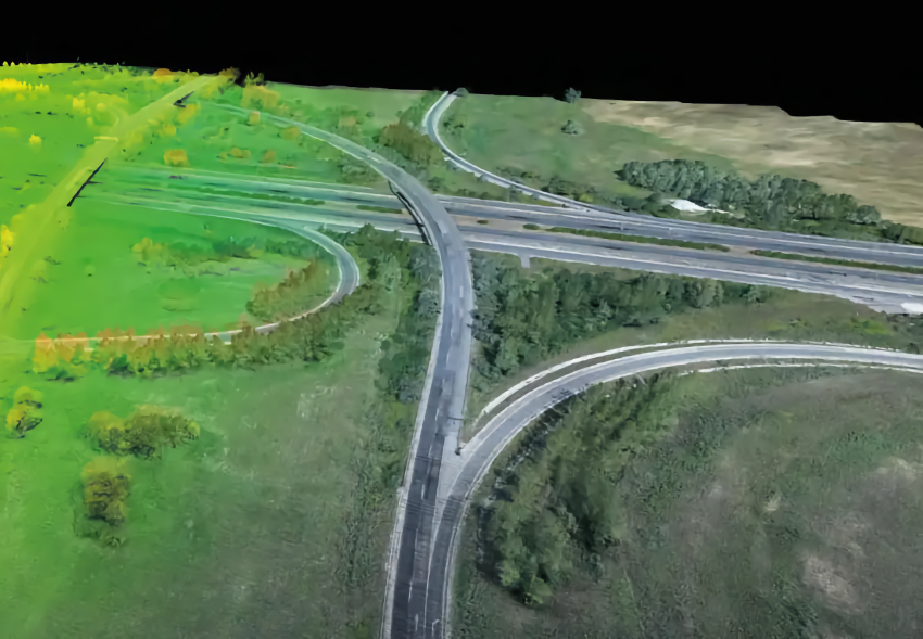
  • Road and Highway Design: LiDAR data helps in designing efficient road networks, identifying potential obstacles, and planning maintenance activities.
  • Railway Construction: Accurate terrain mapping ensures safe and efficient railway construction, reducing the risk of alignment errors.
  • Urban Planning: Detailed 3D models assist in city planning, infrastructure development, and monitoring urban growth.
  • Utility Management: LiDAR aids in mapping utility networks, such as power lines and pipelines, ensuring proper maintenance and minimizing outages.


Aerial LiDAR is revolutionizing infrastructure mapping by providing precise, rapid, and versatile data that enhances project efficiency and accuracy. Its ability to survey challenging terrains, coupled with its cost-effectiveness and environmental benefits, makes it an invaluable tool for engineers, planners, and developers. As the technology continues to advance, the scope of Aerial LiDAR in infrastructure mapping will only expand, paving the way for smarter, more resilient infrastructure solutions.

Embrace the future of infrastructure mapping with Aerial LiDAR and unlock the full potential of your projects. At Graphias Solutions, we are committed to leveraging cutting-edge technologies to deliver superior results for our clients. Contact us today to learn how Aerial LiDAR can transform your next infrastructure project.

Leave a Reply

Your email address will not be published. Required fields are marked *